
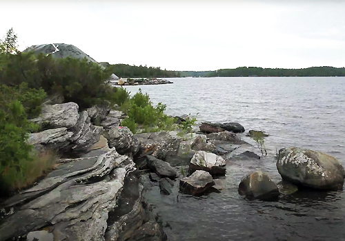
For decades, the rocky north shore of Lake Huron has served as a lab and lecture hall for second-year earth sciences students learning fundamental geological field skills.
But that was before COVID-19.
When pandemic restrictions suspended in-person teaching in mid-March, Dan Gregory, an assistant professor in the Faculty of Arts & Science’s Department of Earth Sciences, set about creating an online version of the two-week field course that was supposed to take place near White Fish Falls, not far from Sudbury.
The course has run for decades and is designed for students pursuing an earth sciences career in research or industry. It teaches basic skills such as how to locate yourself on a map by taking compass bearings on landmarks such as islands or hilltops; how to map a shoreline or geological feature such as an outcropping of rock; and how to take accurate notes while in the field — a skill essential to being a good geologist.
Gregory migrated the course online with the help of two graduate student teaching assistants (TAs) and a work-study student. “I was pretty sure early on that we needed to do something,” he says. “So I started planning this not long after in-person instruction was cancelled. Then in early June, we really started running with it.”
The online version of the course ran throughout August. In place of the mapping exercise that students would have done in the field, they viewed a series of short videos recorded by Gregory in June near Parry Sound. They cover a 1.5-kilometre stretch of Lake Huron shoreline from a different vantage point which students used to draw a geological map of the site. With the map and other observations, the students then constructed a geologic history of the area.
Three-dimensional virtual reality room
For the course’s outcrop mapping module, Gregory and a work-study student created a three-dimensional virtual reality (VR) room by combining existing 3D digital landscapes with the Mozilla Hubs virtual room platform.
The digital landscape contained rock outcroppings, hills, ravines, trees — even a campsite where students could “meet up” with TAs for additional instruction. Students moved throughout the landscape as if they were playing a first-person video game. But instead of battling enemy warriors or dragons, they located and studied five geological features just as they would have in the field.
In other modules, lessons that would have been delivered in the field were turned into short videos featuring a TA and supporting visuals. For example, one instructed students on the fundamentals of studying and documenting core samples.
It allowed us to tap into new technologies such as looking at rock cores — long tubes of rock that were drilled using diamond drills — using an online database set-up by the Minnesota Department of Natural Resources. This meant we were taught vital techniques that we’ll use once we get a job in the geological or mining industries — techniques that weren't taught in the course pre-pandemic.
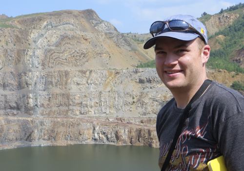
Lukas Louwerse, a member of University College, is entering the fourth and final year of his planetary science specialist program and is continuing on to grad school and a research career focused on the terrestrial planets of the solar system.
“I didn’t need the course for my program,” he says, “but I took it to gain some practical experience with field techniques and instrumentation which will help me understand the design choices and equipment needed for planetary science missions.
“I found that using digital media such as photos, videos and 3D renders was similar to the work I’ve seen using telemetry from various planetary rovers and landers — so this course provided me with valuable insights in that regard.”
Daryll Bien Concepcion, a member of St. Michael's College, took the course to fulfill a requirement for a degree as an environmental geosciences specialist and for registration upon graduation with the Association of Professional Geoscientists of Ontario. He also found a silver lining to the online version of the course.
“It allowed us to tap into new technologies such as looking at rock cores — long tubes of rock that were drilled using diamond drills — using an online database set-up by the Minnesota Department of Natural Resources,” he says. “This meant we were taught vital techniques that we’ll use once we get a job in the geological or mining industries — techniques that weren't taught in the course pre-pandemic.”
The virtual field course provided ample opportunities for students to communicate with Gregory and the TAs and to collaborate with classmates on group assignments. While in the VR landscape, they could talk to each other as they explored the digital terrain. The group also “met” twice a week using Google Meets and interacted via a discussion board.
Unanticipated dividends from online version
About migrating the course online, Gregory says, “It was a lot of work — setting it up as well as troubleshooting and fixing things once the course was underway.”
And while everyone is hopeful the online version is needed only once, the effort may end up paying unanticipated dividends — even after students return to classrooms — by making the course more accessible.
“There are people who might be dissuaded from taking the course because a mobility issue makes it difficult to be in the field,” says Gregory. “Plus there may be people who aren’t comfortable being out in the wilderness for some other reason. This approach could be a useful alternative for them.”
Gregory and other earth sciences colleagues have been hard at work migrating other courses online, solving challenges somewhat unique to their very hands-on discipline.
For example, for his relatively small fourth-year economic geology class, Gregory will be driving around the GTA delivering rock samples to students in person — with safe distancing and masks — because, he says, “Actually holding a real rock is really important. You can’t do that online.”
Geological Field Methods course VR room
For their online geological field methods course, students learn to map rock outcrops in this three-dimensional virtual reality (VR) room that combines existing 3D digital landscapes with the Mozilla Hubs virtual room platform. Video courtesy of Dan Gregory and Sofia Panasiuk.